

As the earth’s sun crosses the equator for the autumnal equinox in the Northern Hemisphere, the end of the summer season transforms into the anticipation of cooler weather, fall festivals and the holiday season. For Mississippi Choctaws, in fact, festivities begin every year in early August.
We celebrate the second Friday in August as Nanih Waiya Day, commemorating the day in 2007 that the Mississippi Legislature sponsored and passed Senate Bill 2732 almost unanimously (with one nay vote in the House) to return the revered “Mother Mound” back to the Mississippi Band of Choctaw Indians. Although the Legislature approved the measure in 2007, the deed to the land wasn’t officially transferred to the tribe until Aug. 8, 2008, or 08/08/08. Miko Beasley Denson—“miko” means chief in Choctaw—and 17 Tribal Council members signed a proclamation later that year officially declaring a new holiday for the Choctaws.

Nanih Waiya, or “leaning hill” in Choctaw, is a burial mound located on State Highway 393 in southern Winston County and is between the Choctaw communities of Crystal Ridge and Bogue Chitto. Tribal members refer to the sacred site as the Mother Mound, as well as the Heart of the Choctaw people.
The mound figures in two differing legends on how the Choctaw people came to be. One is a migration story, where the ancestors came from the West, looking to resettle in the East. Each night a Chief would shove a pole into the ground, and the tribe moved in whichever direction the pole was leaning by the next day. According to this legend, the pole finally stood upright at the site of present-day Nanih Waiya, and the ancestors decided this is where they would settle.
| The tradition of oral history was passed down generation to generation of Choctaws for centuries, and this is how the history and significance of Nanih Waiya was kept. In this video, Wagoner Amos, a distant relative of author Roger Amos, records what was passed down to him in fluent Choctaw language. He explains how the legend of the Nanih Waiya staff inspired songs and dances and instruction to teach children to preserve this tradition. Video courtesy Choctaw Cultural Legacy |
The other creation story involving Nanih Waiya involved the mystical cave mound. Choctaw children learn that various tribal groups emerged from the mound, dried and tanned in the sun, and went in various directions. The Choctaw were the last to emerge, looked around and declared it a good place to settle—“our Mother mound.”
‘Territory of the Red People’
We lost the Mother mound and remaining tribal lands when Choctaw leaders and representatives of the U.S. government signed the ninth and final treaty at Dancing Rabbit Creek in Noxubee County on Sept. 27, 1830. The handover of 11 million acres of Choctaw lands in Mississippi and surrounding states came after eight previous treaties with the United States, all with my people trying to stave off loss of original Choctaw lands to encroaching settlers. Afterward, the former Choctaw territory was opened to white settlement. That also marked the beginning of the “Choctaw Trail of Tears” march to the former U.S.-created “Indian Territory,” now known as Oklahoma.

The state name “Oklahoma,” in fact, is a name formed using Choctaw words, a Choctaw School of Language website explains: “Following the Civil War, delegates from the 5 Civilized Tribes traveled to Washington, D.C., to resume formal relationships with the U.S. government. During the meeting, federal officials proposed the creation of an Indian Territory. Choctaw delegate Rev. Allen Wright suggested naming it ‘Oklahumma.’” The site explains that in the Choctaw language “okla” means “people” and “humma” means “red.”
“Thus,” it continued, “the area would be named Oklahoma Territory, or literally ‘Territory of the Red People.’ Today ‘The State of Oklahoma’ literally means ‘The state belonging to Red People.’”
The Choctaw Trail of Tears lasted many generations and, although beginning in 1830, it lasted even into the early 20th century. The United States, under President Andrew Jackson, forced the Choctaw to emigrate along the dangerous route, with historians pointing to some 2,500 deaths and many others in other tribes forced west. From 5,000 to 6,000 Choctaws stayed behind in Mississippi, eventually forming the Mississippi Band of Choctaw Indians in 1945 after Congress passed the Indian Reorganization Act of 1934. Mississippi Choctaws faced harassment, bigotry and other abuse over the decades while building our own institutions and economic development in our home state.
Not to mention a lot of pride in our history and culture.
Every September, the tribal school system celebrates “American Indian Week,” typically the third week of the month. Celebrations throughout the week on each tribal school campus culminates in an actual holiday Reservation-wide on that Friday. The schools are closed as well as Choctaw tribal governmental offices.

Before my family relocated to Troy, Ala., from Neshoba County, I remember this as only a holiday on the school calendar; we still had our cultural celebrations during the week and got Friday off. In recent years there, several Choctaw communities have started sponsoring community-wide gatherings, with games, songs, and dances reminiscent of the Spring Festivals in April and May. Meanwhile, in Neshoba County where I now live again, and the rest of Mississippi and the world, it’s just another Friday.
Both celebrations for these holidays were scaled back significantly the past couple of years due to the prevalence of COVID-19 on the Choctaw reservation.
‘A Treaty of Perpetual Friendship’
One day that is noted but not “celebrated” is Sept. 27, 1830, the signing of Dancing Rabbit Treaty 192 years ago this week, which devastated Choctaw communities and forced the deadly diaspora west. This treaty may have been the last between the Choctaw Nation and the United States, but it was the first “removal treaty” signed after the U.S. Congress enacted the egregious Indian Removal Act earlier that year. President Andrew Jackson, the namesake of Mississippi’s capital city, signed off on the treaty.
Despite the phrase “a treaty of perpetual friendship” as stated in the document’s preamble, there was nothing friendly about being asked to give up remaining property and move elsewhere just to accommodate new settlers. Another example of a removal treaty is the Treaty of New Echota that took 7,000 acres of ancestral land from the Cherokees, originally of the northern Georgia region, but with a strong presence in North Carolina and other states.

The forced relocation west to what was promised to be Indian Territory reminds me today of the coercion and relocation of Venezuelan migrants to Martha’s Vineyard. The tactics are familiar to what I have learned from history: The government provided documents promising provisions that they never intended to keep. The difference in this diaspora of 2022 is that the Venezuelans are migrants from South America; the Choctaws herded onto the Trail of Tears were indigenous to Mississippi before it ever became a state.
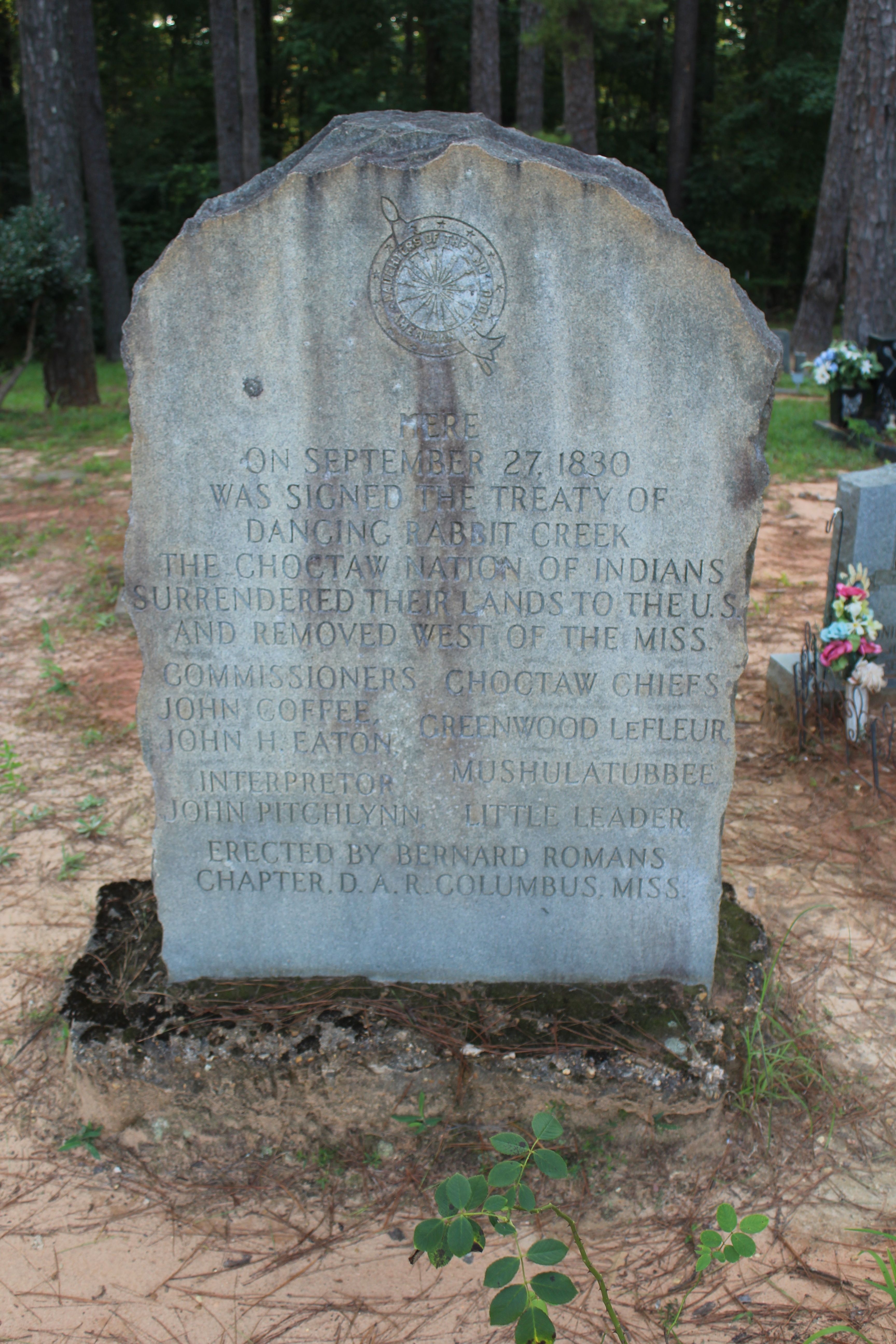
Two historical markers in Noxubee County point to the treaty site from today’s state highways. One is from Highway 21, which is the marker closest to the site and is reported to have been erected in 1991. Another older marker is located on Jefferson Street just south of the city of Macon, the county seat. That marker went up in 1949. There is a monument that a Columbus, Miss., Daughters of the American Revolution group erected at the treaty site where there is also a small cemetery, which is still in use today.
What is remarkable to me is the inaccuracy of both markers.
‘Like a Benighted Stranger, Following False Guides’
Somehow, both of the Noxubee County markers have the same wrong date of Sept. 7, 1830, instead of Sept. 27, 1830, for this pivotal day in American and Choctaw history. How could the same mistake be made twice, 42 years apart? I discovered this error when a smartphone calendar app alerted me to the day’s date, and I was about to write a post about the significance of it and use a personal photo I had taken in 2020 on a quick family road trip to the treaty site.
I could not believe I hadn’t noticed the wrong date at the time I took the photo; likely I just wanted to quickly move from the side of the highway where it is located.

The Mississippi Department of Archives and History website says that, today, historical markers are “privately sponsored and funded.” Once an application is received and the MDAH Board of Trustees approves it, MDAH works with a manufacturer to create the marker. After completion, it is shipped off to the Mississippi Department of Transportation, who then installs the marker at the appropriate historic location.
But that system has only been in place for about 25 years, the Mississippi Department of Archives and History told me this week. So private funders paid for the 1991 treaty marker, but the State of Mississippi had paid for the first one in 1949, the first year of Mississippi’s marker program.
There is no telling how much it cost to erect either of these two erroneous markers from 1949 or 1991, but today’s 30-inch-by-42-inch marker costs are between $2,440 and $2,290, which includes a 7-foot post.
In today’s world where history and facts are hotly debated, including which parts of American and Mississippi’s state history is taught more than others, an insulting historical inaccuracy has been in plain view for more than 70 years. Hopefully, this simple inaccuracy can be easily corrected and the correct date be recognized for its significance and contribution to the development of the state of Mississippi and the effects on the Choctaw people.
What happened on Sept. 27, 1830, was horrifying enough for the Choctaw; the least the State of Mississippi can do is to get the date right on the markers that remain near the treaty site.

In 1831, Mississippi Choctaw George W. Harkins wrote an eloquent but pointed message to the United States about the loss of Choctaw homelands and the forced removal of most of our people: “Although your ancestors won freedom on the field of danger and glory, our ancestors owned it as their birthright. … Yet it is said that our present movements are our own voluntary acts—such is not the case. We found ourselves like a benighted stranger, following false guides, until he was surrounded on every side, with fire and water.
“We go forth sorrowful, knowing that wrong has been done,” Harkins continued. “Will you extend to us your sympathizing regards until all traces of disagreeable oppositions are obliterated, and we again shall have confidence in the professions of our white brethren.”
Still, he wished the state he was leaving behind well before embarking on the Trail of Tears: “Much as the state of Mississippi has wronged us, I cannot find in my heart any other sentiment than an ardent wish for her prosperity and happiness.


